
We have released a consultation on Unmanned Aircraft System Traffic Management (UTM), presenting our initial thoughts on the architecture and regulatory requirements for its implementation. This serves as the first public indication of how the CAA wishes to support the safe, efficient, and scalable integration of UAS into UK airspace traffic management.
If you will be impacted by UTM, whether that be as an operator, a provider of UTM services, or a provider of other data services, please consider responding.
We request that respondents read all 3 documents before providing comments.
We invite stakeholders to give us their views.
Related
Discover more from sUAS News
Subscribe to get the latest posts sent to your email.

On 20 May 2026, the Law Commission published its final report on aviation autonomy. Commissioned by the Department for Transport and the Civil Aviation Authority, the review addresses the legal barriers to safely deploying highly automated and autonomous systems in aviation. It focuses on three main use cases: drones, advanced air mobility such as vertical take-off and landing aircraft (VTOLs), and air traffic management. The overarching aim is to ensure that uncrewed aircraft systems (UAS) can operate with safety levels equivalent to crewed flights.
A central element of the report is drawing a clear line between remotely piloted and autonomous operations. To ensure legal certainty regarding who is responsible for aviation safety, the commission recommends that any flight where a human pilot can intervene should be classed as remotely piloted, while any flight without this possibility is autonomous. It advises retaining the current legal definition of a remote pilot and aligning their responsibilities with those of a commander in commercial air transport operations.
For passenger-carrying remotely piloted operations, ensuring equivalent safety with crewed aircraft is paramount. The remote pilot will hold ultimate legal responsibility for flight preparation checks, such as ensuring the aircraft is airworthy and that cargo is secured. Furthermore, the remote pilot will have the responsibility to refuse transport to individuals under the influence of drink or drugs. They will also be granted the power to take reasonable measures, including authorising passenger restraint under the Civil Aviation Act 1982, to protect the aircraft and its occupants in emergency situations. Operators will be required to ensure that passengers can contact a crew member at all times.
When operations become fully autonomous, the responsibilities of the pilot will shift significantly to the UAS operator. The operator will be required to use an aircraft designed to comply with operational limitations and avoid the risk of collision. Mandatory flight data recorders are also recommended for autonomous drone and VTOL operations to facilitate accident investigations and improve long-term safety.
The report also examines civil and criminal liability when accidents happen. It states that the current strict liability system will continue to function effectively for air carriers, although product liability relating to artificial intelligence requires a broader review. In terms of criminal law, the commission recommends updating the offence of hijacking under the Aviation Security Act 1982. Recognising that uncrewed aircraft could be seized by technological means or hacking without a hijacker being present on board, the report urges the UK to implement the Beijing Protocol to expand the legal definition of hijacking.
Finally, to safely integrate uncrewed flights beyond the visual line of sight, the report calls for legislative change to accommodate the certification of uncrewed aircraft systems traffic management (UTM) providers. These services will supply vital digital information about potential hazards and weather to uncrewed aircraft, ensuring they can share the airspace safely with crewed flights.
Related
Discover more from sUAS News
Subscribe to get the latest posts sent to your email.

At Neuron, we are dedicated to anticipating the future and enhancing our users’ experiences. Recently, 4DSKY has garnered significant attention, with sensor sales surging, a vibrant community engaging more than ever, and new partnerships launching almost weekly. We are excited to unveil the next evolution of the 4DSKY software, set to arrive on your screens in 2026. Stay tuned for innovations that will redefine your experience!
The following is an in-development preview and is subject to change
Starting of with the mood board – Combining organic material with futuristic connectivity


Related
Discover more from sUAS News
Subscribe to get the latest posts sent to your email.

DUBAI, UAE – SkyGrid, an Advanced Air Mobility (AAM) Third-Party Service Provider (TSP) and High Lander Aviation, a global provider of UAS traffic management (UTM) and drone fleet management (DFM) solutions, signed a Memorandum of Understanding (MOU) at the 2025 Dubai Airshow in the UAE. This
collaboration will explore the development of a cutting-edge airspace management ecosystem to support the safe integration of crewed and uncrewed aerial vehicles, including cargo drones and electric vertical takeoff and landing (eVTOL) aircraft.
Under this agreement, the parties will work together to assess Advanced Air Mobility Supporting Operational Environments (SOE), focusing on key areas such as airspace integration, digital operations, vertiport integration, cybersecurity, and regulatory frameworks.
The goal is to develop technology roadmaps, regulatory frameworks, and infrastructure plans for AAM operations in Abu Dhabi and beyond. This partnership not only supports Abu Dhabi’s ambition to lead in next-generation aviation but also contributes to global advancements in airspace integration and autonomous flight technologies.
“This collaboration represents a significant milestone in shaping the digital foundation of Advanced Air Mobility in the UAE and across the Middle East,” said Jia Xu, CEO of SkyGrid. “Together with High Lander, we’re bringing the world closer to a unified vision of safe, scalable, and sustainable airspace integration. By combining SkyGrid’s expertise in high-assurance autonomous flight services with High Lander’s proven UTM technologies, we can help Abu Dhabi realize its vision of becoming a global leader in next generation aviation and autonomous transportation.”
The initiative aligns with Abu Dhabi’s Economic Vision 2030, reinforcing its commitment to technological innovation, economic diversification, and sustainability. By leveraging SkyGrid’s expertise in next-generation digital airspace integration solutions and High Lander’s leading UTM technology, this partnership will accelerate AAM adoption in the region and position Abu Dhabi as a global hub for autonomous air transportation.
“This partnership between High Lander and SkyGrid marks an exciting step forward in advancing a connected and intelligent AAM ecosystem,” said Alon Abelson, CEO and founder of High Lander. “Our shared goal is to create a harmonized operational environment where uncrewed and crewed aircraft can coexist safely and efficiently. The UAE’s leadership and their commitment to innovation, with the support of industry giants such as Boeing, make it the perfect environment to demonstrate how automation,
data-driven management, and cross-industry collaboration can transform the future of air mobility.”
About SkyGrid
SkyGrid exists to open the sky for autonomous flight. Based in Austin, Texas, SkyGrid builds high-assurance third-party services to enable the safe operation and integration of autonomous aircraft. SkyGrid also acts as the operational nexus for Advanced Air Mobility, integrating and managing data, infrastructure, access, and traffic to support scaled operations. SkyGrid is part of Wisk Aero, an Advanced Air Mobility Company, headquartered in California.
For more information, please visit www.skygrid.com
About High Lander
High Lander was established in 2018 by aviation veterans and technology experts with a dream: to safely and effectively integrate UAS into airspaces worldwide. The company is achieving this with two scalable, software-only solutions. The first is Orion DFM, a hardware-agnostic platform for creating, managing, and automating UAS missions for any application and at any scale. The second is Vega UTM, a next-generation UAS traffic management platform that provides airspace authorities with the tools they need
to maintain strict safety standards in increasingly crowded skies.
For more information, please visit www.highlander.io
Related
Discover more from sUAS News
Subscribe to get the latest posts sent to your email.

Terra Drone Corporation, a leading drone and Urban Air Mobility (UAM) technology company headquartered in Japan, is pleased to announce that its group company and a global leader in UAS Traffic Management (UTM) solutions, Unifly, has released a new position paper titled “Navigating the Urban Airspace: UTM as a Catalyst for Urban Air Mobility”. The position paper presents Unifly’s vision and roadmap for enabling safe and scalable next-generation air mobility through advanced UTM solutions.
Background of Unveil the Position Paper
With accelerating urbanization worldwide, there is an urgent demand for faster and more environmentally sustainable modes of transport. Against this backdrop, Urban Air Mobility (UAM)—leveraging technologies such as drones and eVTOL (electric Vertical Take-Off and Landing) aircraft—is rapidly emerging as a key solution for next-generation mobility.
Advancements in battery technology, lightweight materials, and automation are bringing eVTOL aircraft closer to large-scale commercial deployment. However, to realize safe and efficient operations, it is essential to address new challenges such as airspace safety and UTM infrastructure. As a leading UTM provider, Unifly has published this position paper to offer a comprehensive roadmap addressing these critical needs. The company clarifies the role of UTM as “digital infrastructure” that supports both the safety and scalability of airspace, and also provides recommendations for policy and regulatory framework development.
Overview of the Position Paper
The paper mainly covers the following topics and presents Unifly’s solutions and roadmap for the widespread deployment of next-generation air mobility.
Key topics include:
Transforming the Urban Sky
eVTOL aircraft will coexist with manned aircraft, helicopters, general aviation, and drones to offer a new transport option within the complex airspace over cities. With growing urbanization and evolving mobility demands, the foundation for aerial transportation is steadily taking shape.
Market Trends and Technology Advancements
Driven by technological breakthroughs and active investment from both the public and private sectors, UAM manufacturers are scaling up production at a rapid pace, even surpassing helicopter production volumes. New aircraft models—quieter, greener, and more cost-efficient—are increasingly entering the market, with urban ride-share-style air transport services becoming a tangible reality.
Key Barriers to Large-Scale Adoption
The widespread adoption of next-generation air mobility faces several major challenges, which pose significant barriers to seamless integration into existing transportation networks.
- Highly complex environment unique to urban areas
- Difficulty for existing air traffic control systems to manage a large volume of diverse vehicles
- Slow development of landing and take-off infrastructure (vertiports)
- Shortage of qualified pilots for UAM operations
- Absence of globally unified standards
- The delayed phased integration of air traffic management (ATM) and UTM in airspace shared by both manned and unmanned aircraft
Unifly’s Solution and Comprehensive Roadmap
To overcome these barriers, Unifly proposes a comprehensive roadmap to enhance UTM capabilities and enable safe and scalable deployment of next-generation air mobility. Key capabilities include:
- Strategic deconfliction of flight paths to prevent airspace congestion
- Vertiport slot allocation and management
- Optimal deployment and allocation of pilots and aircraft
- Real-time emergency response capabilities
- Preparation for the introduction of “Digital Flight Rules (DFR)” aimed at autonomous and remotely piloted operations
Through these initiatives, Unifly aims to establish a robust and reliable operational management framework that will support both safe and efficient operation of next-generation air mobility in urban areas.
Unifly’s Track Record and Future Prospect
For nearly a decade, Unifly has provided UTM solutions to aviation authorities and Air Navigation Service Providers (ANSPs) across the globe. The company remains at the forefront of next-generation airspace management systems centered on UTM and continues to actively contribute to their realization.
Through this position paper, Unifly aims to engage policymakers, industry leaders, and a wider audience with its strategic vision and to promote collaboration and dialogue toward building a safer and more efficient next-generation air mobility society.
The full the position paper can be downloaded here: https://www.unifly.aero/utm-uam-aam/
Related
Discover more from sUAS News
Subscribe to get the latest posts sent to your email.

London, UK & Lisbon, Portugal: Altitude Angel, a global leader in unified traffic management (UTM) and NexG CSA, part of the NexG Group, have chosen the second day of the Airspace World expo in Lisbon to announce a strategic commercial partnership which will revolutionise the way the sky is managed across Malaysia for a new generation of airspace users.
The combination of Altitude Angel’s GuardianUTM suite of technologies and NexG CSA’s ‘in-country’ expertise will enable the creation of competitive and innovative services aligned with the strategic goals of the Malaysian Drone Technology Action Plan 2022-2030 (MDTAP30), which will allow Malaysia to use and benefit from the array of use cases drone operations can bring.
The GuardianUTM platform will provide real-time situational awareness and data visibility, improving operational efficiency and safety across designated UAS airspace. Through live monitoring capabilities, key stakeholders will have direct insights into UAS activities, helping to maintain public safety while developing and growing the drone ecosystem as part of a new regulated environment for UAS operations.
As the partnership develops, new opportunities will be explored such as the introduction of Altitude Angel’s transformative ARROW technology to the Malaysian peninsula, which when fused with its GuardianUTM platform, detects and identifies all airspace users, enabling drones to fly BVLOS and share the airspace with crewed aviation safely and securely.
On the strategic partnership, Richard Parker, Altitude Angel, CEO and founder said: “Supporting the development of new airspace users across Malaysia and Southern Asia is one of our strategic priorities. This partnership with NexG CSA is a milestone in the development of Malaysia’s airspace, bringing together the technology, innovation, and local expertise which will provide the foundation for a new and exciting drone economy.”
On behalf of NexG CSA, its CEO Dato’ Syahril Abdullah, commented, “We are pleased to enter into this strategic partnership with Altitude Angel, a global leader in unified traffic management solutions. This collaboration represents a significant step forward in supporting the growth of drone-related services and capabilities, aligned with our broader national ambitions. By integrating advanced UTM technologies, we aim to enhance airspace safety, improve operational visibility, and support the safe and scalable integration of drone operations. As the partnership evolves, we look forward to exploring new opportunities that will further strengthen the ecosystem and unlock the full potential of drone technology in Malaysia.”
Related
Discover more from sUAS News
Subscribe to get the latest posts sent to your email.

Kongsberg Geospatial is celebrating the expansion of its Kanata offices with a ribbon-cutting ceremony on May 1, 2025. The new space marks a significant step in the company’s continued growth and commitment to innovation, collaboration, and leadership in Canada’s defence and aerospace sectors.
Kongsberg Geospatial announces the opening of its expanded Kanata office with a ribbon-cutting event on May 1, 2025, celebrating growth, innovation, and its evolving role within the Kongsberg Group.
Kongsberg Geospatial, a leading Canadian developer of mission-critical geospatial, defence and security technologies that is part of the Kongsberg Group, is pleased to announce the official opening of its newly expanded office space in Kanata’s high tech hub. To mark this milestone, the company will host a ribbon-cutting ceremony on May 1, 2025, from 6:00PM to 8:00 PM, welcoming invited guests from industry, government, and media.
This expansion comes as Kongsberg continues to grow both its employee base, and capabilities in Canada, beginning with the recently announced NAV Canada Digital Aerodome Air Traffic Services project, in collaboration with Kongsberg Defence and Aerospace in Norway. The project will be the largest remote digital air traffic management system in the world, positioning NAV Canada, Kongsberg and by extension Canada at the leading edge of the next generation air traffic services.
The office expansion provides room for future innovation, collaboration, and operational scale, and reinforces the company’s evolving role as the face of Kongsberg in Canada. Kongsberg Geospatial is excited to continue serving as the primary point of contact for Canadian partners, clients, and stakeholders across the country on behalf of the broader Kongsberg Group.
“This new space reflects the growth we’ve experienced in recent years, but more importantly, it signals our commitment to the future,” said Jordan Freed, President of Kongsberg Geospatial. “As we take on a larger role within the Kongsberg ecosystem, this expansion sets the foundation for even greater collaboration across defence, aerospace, and civil markets here in Canada.”
The ribbon-cutting will also feature remarks from Kjetil Reiten Myhra, President of Kongsberg Defence & Aerospace, highlighting the strategic importance of the Canadian market and Kongsberg’s long-standing investment in local talent, partnerships, and innovation.
Guests attending the private ceremony will have the opportunity to tour the new floor, network with Kongsberg leadership, and learn more about the company’s vision and direction.
Related
Discover more from sUAS News
Subscribe to get the latest posts sent to your email.
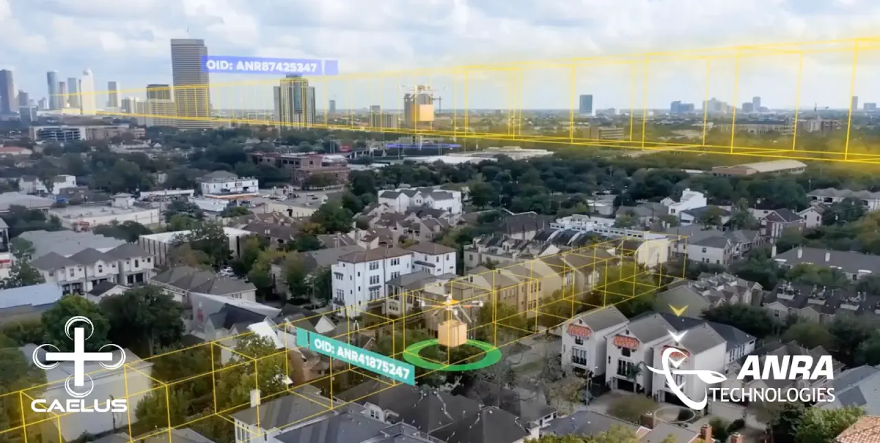
ANRA Technologies is proud to announce its significant role in successfully completing the two-year Care & Equity, Healthcare Logistics UAS project (CAELUS), funded by UK Research and Innovation (UKRI). This groundbreaking two-phase initiative focused on advancing airspace integration and delivery management services for drones delivering medical products for the National Health System (NHS) Scotland, paving the way for scalable, safe, and efficient drone operations in the United Kingdom.
ANRA’s contributions centered around supporting the development and validation of airspace management solutions using Unmanned Traffic Management (UTM) and delivery management systems. The company’s cutting-edge Delivery Management System (DMS), integrated with its UTM platform, enabled complex Beyond Visual Line of Sight (BVLOS) medical delivery operations, connecting key stakeholders such as NHS Scotland, delivery drone operators, and end users.
Key achievements and contributions from ANRA include:
- Enhancing NHS Operations: ANRA’s DMS facilitated seamless coordination between NHS customers, suppliers, and drone operators, validating the system’s ability to support critical medical use cases.
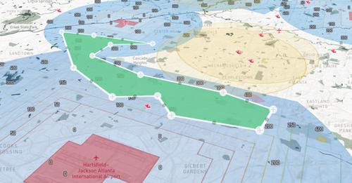
- Participation in Four CAELUS Trials: ANRA supported and participated in major trials across Scotland, including Glasgow Airport, Crosshouse to Arran, Edinburgh to the Borders, and Aberdeen to Elgin.
- UTM-ATM Interoperability Solutions: Leveraging its expertise in open interoperability standards, ANRA developed and tested UTM-ATM interoperability solutions during the Crosshouse and Aberdeen trials. These trials showcased the ability to integrate drone operations within existing air traffic management (ATM) frameworks.
The CAELUS project achieved groundbreaking results by reaching several critical milestones. Notably, ANRA’s UTM platform was successfully integrated into the project’s Concept of Operations (ConOps), establishing a solid foundation for future airspace management frameworks. Additionally, the project demonstrated the execution of complex BVLOS operations, with ANRA’s DMS, enabling seamless data exchanges with ATM systems. This capability ensured efficient and safe drone flights in highly regulated airspace, as showcased during the Crosshouse and Aberdeen trials.
One of the project’s most notable achievements was completing the UK’s longest onshore BVLOS drone flight. The operation featured two segments, with an intermediate landing at a charging station, managed entirely through ANRA’s integrated DMS and UTM solutions. This accomplishment demonstrates ANRA’s commitment to enabling reliable drone operations for essential services and their interoperability with multiple technology partners.
“We are proud to have contributed to the CAELUS project and its transformative work in advancing drone integration for medical deliveries,” said Dr. Ajay Modha, Head of Business UK at ANRA Technologies. “The successful trials and demonstrations highlight how our solutions can enable scalable, safe, and efficient drone operations, particularly in critical use cases like healthcare.”
The CAELUS project’s success represents a major step forward in realizing the potential of drones to enhance healthcare delivery, reduce transportation times, and improve patient outcomes in the UK and beyond. Led by AGS Airports, ANRA was honored and grateful to have supported terrific partners during CAELUS 1 and 2 that included:
- AGS Airports
- NHS Scotland
Atkins - Cellnex
- Commonplace
- Connected Places Catapult
- DGP Intelsius
- Dronamics
- Arup
- Planefinder
- Skyports
- The DroneOffice
- NATS
- Trax International
- University of Strathclyde
About ANRA Technologies
ANRA Technologies is a leading provider of airspace management and mission management solutions for unmanned aircraft. With a portfolio of innovative platforms, including UTM, DMS, and more, ANRA empowers organizations to safely and efficiently operate drones and other aerial systems in shared airspace.
To learn more visit ANRA’s web site: www.anratechnologies.com
Related
Discover more from sUAS News
Subscribe to get the latest posts sent to your email.
We are thrilled to announce that Aloft has successfully completed the FAA LAANC onboarding for the latest version of LAANC. As the #1 LAANC provider, having processed over 1.4 million authorizations, Aloft continues to lead the way in airspace management. Since becoming a UAS Service Supplier (USS) in 2018, we have been at the forefront of innovation and service in the uncrewed aircraft systems (UAS) industry, serving as the mission critical platform across recreational, commercial, government, and public safety access to airspace.
The latest version of LAANC introduces several exciting new features, particularly for Part 107 operators and those utilizing further coordination requests. We have long advocated for greater utility and efficiency in these areas, and we are pleased to see these enhancements come to fruition.
New Features in the Latest LAANC Version
Improved Further Coordination Requests
One of the key areas we have focused on is the further coordination request process. Our advocacy for better response and approval rates has led to significant improvements, which we have documented over the last few years in the Aloft “State of LAANC” reports.
In this latest version of LAANC, we’re excited to note two key improvements around further coordination.
1. Reduced Expiration Time: The automatic expiration of further coordination requests has been reduced from 24 hours to 3 hours. This change provides Air Traffic Control (ATC) with more opportunities to review and approve requests promptly, enhancing the overall efficiency of the process.
2. Enhanced ATC Feedback: ATC can now send feedback on why a request was denied, with specific guidance such as “to resubmit 100ft lower.” This feature allows operators to understand and adjust their requests more effectively, increasing the likelihood of approval on subsequent submissions.
These new capabilities are designed to improve the experience for UAS operators, providing more timely and actionable information to facilitate safe and efficient operations.
Live Today Across the Aloft Air Control Platform
We are excited to announce that all of these new capabilities are live today across the Aloft Air Control platform. Whether you are using our iOS or Android mobile apps or accessing advanced and enterprise LAANC capabilities via the web at air.aloft.ai, you can take advantage of these enhancements immediately.
At Aloft, we are committed to continuously improving our services and supporting the evolving needs of the UAS community. We are proud to be your trusted partner in airspace management and look forward to continuing to lead the industry with innovative solutions and unparalleled service.
Stay tuned for more updates and insights from Aloft as we continue to advance UAS operations and airspace safety.
Discover more from sUAS News
Subscribe to get the latest posts sent to your email.

Netherlands favourite flight planning app to relaunch with enhanced user experience and industry-ready flight planning tool set
Geneva, Switzerland: Netherlands ANSP LVNL and Altitude Angel, the world’s most trusted UTM (Unified Traffic Management) technology provider, have chosen the second day of Airspace World to announce the release of a new and improved version of the popular flight planning tool, GoDrone, bringing a host of new features which will give users an even greater understanding of the country’s airspace and access to it.
Designed and powered by Altitude Angel, GoDrone has established itself as the flight planning app for professional and recreational drone pilots across the Netherlands since its launch in April 2020.
“Planning is central to all commercial drone operations within a civil CTR, and any operator should start their flight plan with GoDrone, which is why we’re continuing to invest in the app,” said Wouter Pekela, Program Manager Unmanned Aviation, LVNL.
The new version of GoDrone, which begins rolling out in Q2 for both iOS and Android, is the most extensive update since the app was first launched and includes several enhancements and exciting new features.
The suite of updated features includes enhanced integrated flight planning, advanced flight plan drawing tools, and approval services – the ability to request access to fly digitally in airspace such as an airport CTR– through the app.
These updates make the app more user-friendly and intuitive for novice pilots, whilst providing several business-critical services for more experienced and professional operators.
In addition to enhanced integrated flight planning & drawing tools, GoDrone also includes new ‘pilot profiles’ and aircraft management, which provides users with the ability to log drone operator profiles, hours flown, and airframe hours used. These features are particularly useful for professional drone operators who may be required to manage or evidence their operational experience and help in managing airframe service intervals and the like.
Other upgrades and new features also include:
- New UXUI -Completely rebuilt modern user interface.
- New Accepted and Approved statuses, allowing GoDrone users to be able to receive more digital updates and information on their mission requests.
- New Map Types including Satellite Maps to help you plan your drone flights safely and efficiently.
- Advanced filter setup allows you to fully customise your airspace to suit your preferences, including political border and NOTAM’s.
- Airframe Hanger – Ability to now input and save all of drones directly in the GoDrone APP.
- GoDrone Operator Portal Integration – Information, edits and missions are natively linked between the GoDrone APP and Operator Portal.
- Ground Hazards – Understand ground hazards in greater details, The Godrone now displays a list of ground hazards in the pre-flight report, each is clickable, providing users with more detailed information.
- New Area reports feature which gives you a simple-to-understand view of where you can fly safely, where you need to exercise caution or areas that are prohibited.
- Enhanced Security (Biometrics) Utilise the latest security features on your phone or tablet, including eye and fingerprint access.
- New flight plan tools- Maximise your flight planning by using advanced drawing tools, or upload files directly from your device
About Altitude Angel
Altitude Angel is an award-winning provider of UTM (Unified Traffic Management) software, enabling those planning to operate, or develop UTM/U-Space solutions, to quickly integrate robust data and services with minimum effort.
Today, Altitude Angel’s market-defining technology is providing a critical, enabling service on which the future of UTM will be built across the globe. Altitude Angel is leading a consortium of businesses to build and develop 165 miles (265km) of ‘drone superhighways’ connecting airspace above Reading, Oxford, Milton Keynes, Cambridge, Coventry, and Rugby over the next two years. The Skyway superhighway network, enabled using Altitude Angel’s patented ARROW technology, will unlock the huge potential offered by unmanned aerial vehicles and be a catalyst to enable growth in the urban air mobility industry.
Altitude Angel’s first party solutions also power some of the world’s leading ANSPs, aviation authorities and Enterprises, including LVNL (Netherlands) and Avinor (Norway), empowering them with new capabilities to safely manage and integrate drone traffic into national operations.
By unlocking the potential of drones and helping national aviation authorities, ANSPs, developers and enterprise organisations, Altitude Angel is establishing new services to support the growth in the drone industry.
Altitude Angel was founded by Richard Parker in 2014 and is headquartered in Reading, UK.
Altitude Angel’s developer platform is open and available to all at https://developers.altitudeangel.com
]]>