
New agreement of cooperation will provide framework for advancing remote pilot training and proficiency standards for America’s first responders
FREDERICK, MD – February, 2022 – The Airborne Public Safety Association (APSA), a 501(c)3 non-profit organization with over 50 years of experience supporting public safety aviation, and the Airborne International Response Team (AIRT), a 501(c)3 non-profit organization supporting the use of drones and robotic systems for public safety and disaster response, have entered into an agreement of cooperation to support the implementation of the National Institute for Standards and Technology (NIST) Test Methods for Small Unmanned Aircraft Systems (sUAS) to enhance safety and remote pilot proficiency surrounding public safety drone operations.
Under the agreement, APSA and AIRT – the official home of the DRONERESPONDERS program – will cooperate to facilitate validation and dissemination of the NIST test methods for sUAS. This will include developing best practices for using the tests to support training with standard measures of remote pilot proficiency for public safety and emergency services organization operating drones for life safety missions.
“The NIST test methods for sUAS have emerged as a proven system for evaluating both remote pilot proficiency and aircraft capabilities,” said Daniel Schwarzbach, Executive Director and CEO, APSA. “Our partnership with AIRT and the DRONERESPONDERS program will help expand awareness and adoption of the NIST test methods while also ensuring a safer National Airspace System (NAS).”
APSA is already offering basic and advanced-level proctor training courses for public safety agencies looking to adopt the NIST test methods for sUAS, as well as a Basic Proficiency Evaluation for Remote Pilots (BPERP) certification. The DRONERESPONDERS program, in-part through a grant from NIST, will help validate and disseminate the test methods while supporting the courses. They will also maintain a record of public safety agencies and personnel who have successfully completed the training.
“We look forward to working alongside APSA to help establish much-needed standardization surrounding public safety and emergency drone operations,” said Chief Charles Werner (ret.), Director, DRONERESPONDERS. “The skill development and objective measures of proficiency provided by the NIST test methods are ideal for law enforcement, fire service, and other public safety agencies who are typically operating small, quad-copter drones.”
The NIST test methods for sUAS provide a scalable, flexible, and reproductible way to train and measure remote pilot proficiency for both professional and recreational pilots, while also reducing risk to ground personnel and manned aircraft operating in the NAS. NIST test lanes can be fabricated easily from supplies typically found at most hardware stores. APSA and AIRT will begin aggregating the average scores for remote pilots on various aircraft within the NIST test methods to enable any organization using similar aircraft to establish their own minimum thresholds of proficiency.
“We are excited to have APSA and DRONERESPONDERS work together to introduce the NIST test methods for sUAS to America’s first responders operating drones,” said Adam Jacoff, a robotics research engineer in NIST’s Intelligent Systems Division who is leading an international effort to develop standard tests for remotely operated aerial, ground, and aquatic systems. “Their efforts will help make public safety drone operations more effective, and safer, for all stakeholders.”
About AIRT
Based in Miami, Florida, AIRT® (Airborne International Response Team) is a 501(c)3 non-profit organization supporting the use of unmanned systems for public safety and disaster response. AIRT offers a wide range of educational programming, training events, and mission-critical deployments that help people prepare for, respond to, and recover from complex emergencies and major disasters. AIRT is the official home of DRONERESPONDERS®, the world’s fastest-growing non-profit program dedicated to the support of public safety drone programs. For more information, visit http://airt.ngo and http://droneresponders.org
About APSA
The Airborne Public Safety Association – APSA – is a 501(c)3 non-profit educational, individual membership organization, founded in 1968 to support, promote and advance the safe and effective utilization of manned and unmanned aircraft by governmental agencies in support of public safety operations through training, networking, advocacy and educational programs. Over 3,000 members strong from the international to the local level, APSA provides networking systems, educational events, and product expositions that public safety aviation professionals find invaluable. For more information, visit: http://publicsafetyaviation.org
Picture this: A person is lost in the desert. Local first responders initiate a search and rescue operation. As they conduct the search, they’re faced with a problem: loss of broadband signal.
This isn’t a made-up scenario. First responders often work in conditions where communication networks are weak or not available. One possible solution is to use drones to deploy broadband networks, making signals available anywhere. But today’s drones often can’t provide adequate support to first responders. The equipment is too heavy for drones to carry for very long.
To help solve the largest challenges facing the first responder community, NIST often turns to private companies, academic researchers, hobbyists, and others via open innovation prize challenges. This time, the First Responder Unmanned Aircraft System (UAS) Endurance Challenge addressed the obstacle of extending the flight time for drones that carry heavy payloads. The objective for challenge participants was to design, build and fly a UAS that could carry a 10-pound (4.5-kilogram) communications device to deploy broadband coverage for as long as possible to transfer critical data files to the first responders. And as part of the challenge, participants were tasked with overcoming difficult technical requirements including weight restrictions, vertical takeoff and landing, an ignition kill system, and an appropriate fuel system, all while ensuring cost-effectiveness.
Forty-three teams entered the competition, of which five final competitors spent a total of 14 months designing and building lightweight drones that go beyond today’s technical capabilities by flying continuously for 90 minutes or longer with heavy payloads. The prize challenge competitors built their systems with the intention of providing broadband service to boots-on-the-ground first responders when they lack network or bandwidth. This includes servicing areas with a lack of cellular network coverage or where cellular infrastructure has been compromised due to a natural disaster, or areas with limited backhaul connectivity, which links the main network to remote locations.
Investing in Ingenuity: The Winning Competitors
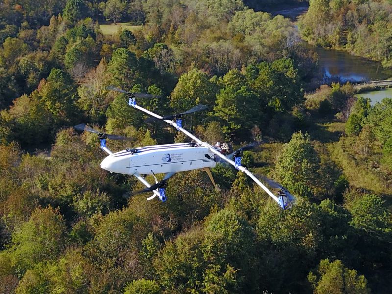
The competition’s top prize went to Team Advanced Aircraft Company (AAC), which received $100K for its six-rotor drone with propellers on each arm. AAC is a veteran-owned company based in Hampton, Virginia, that specializes in building American-made drones that enable longer flights through their hybrid-electric propulsion system. The company builds UAS devices that are quick to set up and easy to use for its customers, including members of the public safety community. Unlike some other prize challenge competitors, AAC’s drone is not a prototype but a product it currently is selling.
The other top teams in the competition included Team Intelligent Energy (IE), which received second place and $40K for its six-rotor drone with a hydrogen fuel system, long-endurance, and lifting capabilities. Team Autonomous Robotics Competition Club (ARCC), from Pennsylvania State University, took third place and received $20K for its multirotor, gas-electric hybrid drone. Team Endure Air also contributed to the UAS competition with its single-rotor helicopter drone.
In addition to the overall prizes, NIST awarded eight Best in Class awards, worth $5K each:
- Endurance: Team AAC had a flight time of 112 minutes and 17 seconds in the “Last Drone Standing” technical flight.
- Innovation: Team AAC received this award for addressing all stage four criteria, taking into account all drone specifications while maintaining a high regard for the public safety mission.
- Weight: Endure Air’s UAS was 29.93 pounds (13.58 kilograms), the lightest of the competition.
- Autonomy: Team ARCC received this award for the success of its preprogrammed flight paths, obstacle avoidance and automatic orbits.
- Ease of Use: Endure Air took only four minutes and 30 seconds to put its UAS into an operational state, from packaging to flight-ready.
- Cost-Effectiveness: Endure Air’s UAS costs less than $5,000 to build.
- First Responder Award: AAC and ARCC were both awarded for their successes in public-safety-focused areas such as responsiveness, special features, and unique design elements.
The solutions developed by the four winners will increase UAS duration, payload, transmission rate and total transmission distances. With these new capabilities, the public safety community and first responders will have access to the tools they need to help save lives in search and rescue situations. “It’s very challenging to build a drone to the required first responder specifications,” said Dereck Orr, chief of NIST’s Public Safety Communications Research division. “Given the circumstances and restrictions, 112 minutes of flight time is extremely impressive.”
NIST regularly uses prize challenges to solve public safety problems. These competitions result in lasting partnerships with companies and academia to leverage for future innovations. And these partnerships help NIST advance critical research and development efforts that create conditions for economic growth and opportunity in the public safety domain.
More information about the UAS Endurance Challenge winners and their drones can be found on the NIST website.
Three New Drone Competitions
The latest UAS prize challenge, the First Responder UAS Triple Challenge, is open now and accepting submissions through Sept. 30. This challenge, also known as UAS 3.0, comprises three separate competitions:
- Challenge 1 — FastFind: UAS Search Optimized
- Challenge 2 — LifeLink: Providing Mobile UAS Data Wherever Lives Are on the Line
- Challenge 3 — Shields Up! Securing Public Safety UAS Navigation & Control
UAS 3.0 will help first responders’ search and rescue missions by improving search capabilities in areas with dense foliage, increasing broadband connectivity to get critical data to first responders, and protecting systems from potential cyberattacks. To learn more about the competition and to enter, visit the UAS 3.0 website.
UAS 4.0 will also be launching soon, but we need your feedback! Are you a first responder or innovator? What UAS technology do you think needs improvement? What public safety problem needs solving? Let us know by writing to us at [email protected].NIST PSCR UAS Endurance Challenge Final Results & Recap
The final results and a recap of NIST PSCR’s 2020 UAS Endurance Challenge competition.
]]>
By Matt Bailey
Just over one month ago, on 24th June 2021, residents in the densely populated area of South Moravia, Czech Republic, had their lives uprooted. They were hit by a natural disaster uncommon on this scale in Europe, a tornado with winds of at least 219km/h (136 mph).
The devastation it caused left thousands of damaged homes behind, and in some cases, destroyed whole city quarters. It flipped cars over, lifting them and throwing them into trees that had managed to stay in place. It created an apocalyptic scene that was unimaginable in a region known for its wine production and unique culture.
When the incident was first reported at 7.23pm, firefighters were immediately dispatched, and from that moment on thousands of professionals and volunteers were on hand to deal with an area of wreckage approximately 26 square kilometers (10 square miles), the equivalent of more than 4,800 football pitches. A total of 2,000 professional firefighters from all over the Czech Republic and approximately the same number of volunteer firefighters, alongside many locals and people offering help, took turns to do their utmost in the affected area. The Fire Rescue Services of the Czech Republic deployed approximately 550 pieces of equipment at the scene.
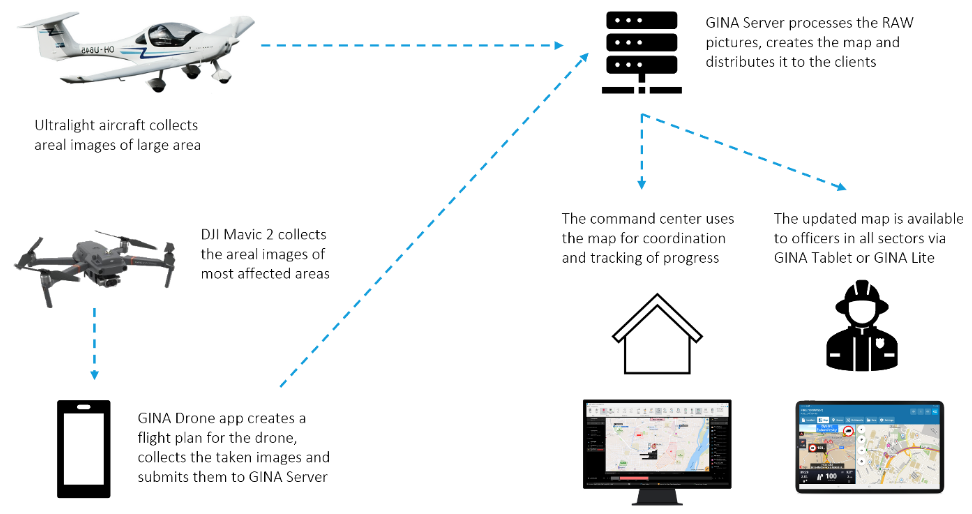
This was also the very first time that Czech Fire Rescue Services had combined DJI’s drone technology with aerial mapping GINA software.
We asked Col. David Jirous, the head of KOPIS (Operational and Information Centre) of South Moravia, to tell us more…
-Can you describe the scene in your own words?
“It was something unimaginable because tornadoes are very rare in our area. Houses were destroyed, trees uprooted, and debris was left everywhere.”
“In the first phase it was very difficult, there was a lack of forces and resources, but above all, we had very little idea of the size of the affected area. Therefore, drones were subsequently used to map the terrain and create a real-time digital map of the devastated area.”
-What time did you first start using the drone and mapping software?
“The DJI Mavic 2 Enterprise DUAL took off shortly after dawn the following day, when the light conditions allowed us to take images of the devastated landscape.”
-How long have you been using drone technology and GINA software?
“Fire rescue services in the South Moravian Region have been using GINA technology since 2012 and drones since 2018.”
-What benefits do drone technology and GINA software give you that you wouldn’t usually have access to?
“Thanks to the use of drones, we have almost immediately an aerial perspective and digital map of the affected area which is distributed to the GINA app. This is accessed by firefighters in the field and the local command center for an accurate picture of the scene and location tracking. We had an up-to-date overview of the affected area, the amount of damage and the force and resource requirements. Thanks to technology we can react flexibly to altering situations in the field.”
“In general, GINA significantly improves the efficiency of both routine and special operations, reduces arrival time, provides real-time information support, and increases the level of cooperation among all responding units.”
-If you didn’t use aerial technology and GINA software, how long would it usually take you to map an area of this size and how would you do it?
“Considering the size of the affected area (over 26 km), which includes difficult to reach isolated areas, it would be very time-consuming to map by purely ground-based means. We’re talking about days rather than the hours it actually took. If we didn’t use drones, we would have to rely on people reporting back from the area where they were working.”
-Is there any additional information you’d like to give?
“Thanks to the experience gained from mapping areas damaged by tornadoes, we want to apply this knowledge to the project we are currently working on, which focuses on automatic mapping of the marked area in GIS or in GINA Tablet. A unique feature of this project will be the time it takes for the digital map to get to first responders in the field. We would like to distribute the data from the drone to GINA apps in near real time using a fast mobile connection such as 5G and LTE networks, or on a local network.”
For further information or interview requests please email [email protected]
]]>