By Hannah Briggs for the Just Drones team — updated 20 May 2026
Quick verdict: The Just Drones team’s collective view on the HS720R — its the HS720E with mildly improved transmission and tuned firmware. Not a generational leap, but solid value if you cant justify a DJI.
Specs at a glance
| Weight | 495g |
| Camera | 4K EIS |
| Flight time | 26 min |
| Transmission | ~1.5km clean |
| Approx. AUD | $399+ |
Holy Stone HS720R review
$399+ AUD
What’s good about it
Updated transmission is a real improvement
Tested side-by-side with our original HS720E — the R variant held signal at ~1.6km where the E broke up at ~900m.
Camera firmware tuning is genuinely better
Less aggressive contrast curve, more usable raw footage.
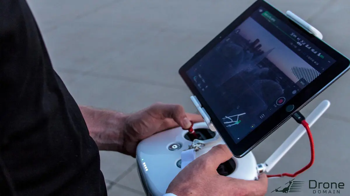
Bundled controller is solid
Standalone phone-cradle, big sticks, doesn’t feel cheap.
Holy Stone’s spare parts and after-sales are credible in AU
Probably the best non-DJI commercial support we’ve seen across team’s projects.
What’s not so good
Still 495g so still needs CASA registration
No free pass on the paperwork — its $40/year per drone.
EIS, not gimbal
Yaw shots still judder. Dont expect Mavic-class smoothness.
Camera in low light is rough
Daylight only for usable footage.
Premium creep over the HS720E
HS720E was $350. The R is closer to $400. The DJI Mini 4K is in striking distance at $399.
Who should buy this
You’ve ruled out DJI for any reason, you specifically want >250g for longer transmission, you trust Holy Stone’s AU support.
Who should skip
You’re DJI-curious — get a Mini 4K or refurb Mini 3 instead.
Heads up: the buy button above goes to Amazon Australia with the Just Drones team’s affiliate tag drones02-22. Costs you nothing extra; pays for the gear we crash during testing.
Related reading from the Just Drones team
]]>
By Marcus Yeo for the Just Drones team — updated 20 May 2026
Quick verdict: Hands down the most fun-per-dollar drone in the Just Drones team’s entire kit. Sub-$250, indoor-friendly, surprisingly cinematic.
Specs at a glance
| Class | 1S cinewhoop |
| Camera | BetaFPV ELRS RX + analog cam (HD variants exist) |
| Weight | ~35g |
| Battery | 1S 530mAh LiHV |
| Approx. AUD | $219+ |
BetaFPV Pavo Pico review
$219+ AUD
What’s good about it
Pulls off cinematic shots indoors that no DJI can match
Tight stairwells, between furniture, through doorways. The Pavo Pico’s enclosed-prop format and 1S size makes it work in rooms where the Avata 2 is too big.
Cheap to crash
Replacement frame is $25. Replacement motor is $8. Crash hard, replace cheap, keep flying. Have replaced three frames this year alone.
Ridiculously quiet
Indoor sound is barely louder than a fan. Wedding venue or event filming where you dont want the drone announcing itself — this is the one.
ELRS RX included means it pairs with any modern FPV radio
Bind to a Radiomaster Boxer / Pocket / TX16S in under a minute.
What’s not so good
Camera is analog at base price
HD variants exist (HDZero, Walksnail) but push the price toward $400. Base analog footage looks like 1998.
3-minute flight time
Real-world 2.5-3 min per 530mAh LiHV pack. Five batteries minimum for a session.
Indoor only
Outdoor wind kills it. Above 10 km/h breeze, the Pavo Pico drifts unpredictably.
Battery-life-per-cell is harsh on packs
We’ve burned through 1S LiHVs at twice the rate of 6S Tattu packs. Plan budget.
Who should buy this
Indoor cinewhoop footage, wedding video, real estate interior shoots, or just a Saturday afternoon of indoor chasing.
Who should skip
Outdoor work, or you want a single drone that does everything.
Heads up: the buy button above goes to Amazon Australia with the Just Drones team’s affiliate tag drones02-22. Costs you nothing extra; pays for the gear we crash during testing.
Related reading from the Just Drones team
]]>
By Liam Carver for the Just Drones team — updated 20 May 2026
Quick verdict: I am the Just Drones team’s least-experienced FPV pilot — by some margin — so the Mark5 HD O4 has been on loan to me as the test bench for whether DJI digital FPV is approachable for a competent-but-non-FPV pilot. Verdict: yes, with caveats.
Specs at a glance
| Class | 5-inch freestyle |
| Video | DJI O4 Air Unit pre-installed |
| Form | Bind-N-Fly |
| Battery | 6S 1300mAh |
| Approx. AUD | $499+ |
GepRC Mark5 HD O4 review
$499+ AUD
What’s good about it
DJI O4 video downlink is night-and-day vs analog
Crystal-clean HD downlink, low latency, no static. Once you fly digital you can’t go back — at least i couldnt.
Frame layout is purpose-built for the O4 module
Cable routing is tidy, antenna placement is correct from the factory. We’ve seen DIY O4 conversions with much worse layouts.
Standard GepRC frame durability
GepRC frames hold up. Even my crashes have left the structure fine.
Tuned for cinematic + freestyle hybrid
PIDs are dialled for smooth cinematic moves while still allowing real freestyle. Better stock tune than most O4 builds the team has flown.
What’s not so good
Total kit cost is steep
Drone + radio + DJI Goggles 3 + batteries comes to $1,300-$1,500. DJI digital is not a cheap path.
Locked into DJI goggles
You need DJI Goggles 2, Integra, 3 or N3 to receive O4 video. No analog backup.
Spare DJI O4 modules are expensive if you crash one
Cable damage or board strike on the O4 unit is a $300+ replacement. Have already replaced one personally.
Newer pilots over-rely on the HD video and crash differently
Analog gives you depth cues from static. DJI digital is too clean — pilots transitioning misjudge proximity. Take it from someone who has.
Who should buy this
You have FPV stick time, you want cinematic freestyle, and you’ve already invested in DJI goggles.
Who should skip
First FPV drone or budget under $1,000 total kit.
Heads up: the buy button above goes to Amazon Australia with the Just Drones team’s affiliate tag drones02-22. Costs you nothing extra; pays for the gear we crash during testing.
Related reading from the Just Drones team
]]>
Little Arms Studios, a leading developer of professional-grade simulation solutions, today announced a new partnership with FPV Australia which will see the leading Australian RPAS certification provider deploy Little Arms Studios’ Zephyr Drone Simulator to enhance its sUAS training programs. With the unique capabilities of the enterprise-level Zephyr Drone Simulator, FPV Australia will be able to ensure necessary proficiencies in its certified pilots while streamlining instructor-student interactions and efficiently tracking student performance through Zephyr’s proprietary Learning Management System (LMS).
The Zephyr Drone Simulator includes training modules equally suited to both novice and veteran sUAS pilots looking to confidently and safely develop their skills, making it the preferred solution for colleges and universities, public safety and disaster relief agencies, as well as numerous professional flight schools training commercial drone pilots. The leading RPAS certification and drone instruction school in the country, FPV Australia will utilize the Zephyr Drone Simulator and its integrated LMS module to further enhance the learning experience for its students.
“The opportunity to give all of our students access to world class simulation as part of their training, means they are far better equipped to operate drones safely,” said FPV Australia’s Chief Instructor, John Fleming. “Being able to coach them during their simulator time before they even arrive at the school, means we can get them way ahead of the game before they start to fly a physical machine. When we approached Little Arms Studios, they were very open to building us a solution that would work for our business model that allows us to offer our students world class training both in and out of the classroom.”
The Zephyr Drone Simulator features a progressive curriculum that starts with the most simplistic elements of drone flight such as takeoff, hover and landing, before moving students on to more complicated mission objectives. To ensure the most realistic training possible, Zephyr can simulate unexpected weather shifts such as heavy rain or high wind gusts as well as randomized component failures that may occur during actual flights. To help instructors train students on applicable federal regulations, Zephyr’s integrated monitoring system will alert pilots to any violations during each mission. Available on Windows and Mac systems, the Zephyr Drone Simulator supports most popular commercial sUAS transmitters and numerous consumer-level controllers.
For drone flight schools such as FPV Australia and others offering online instruction, Zephyr’s enterprise version also features Little Arms Studios’ proprietary Learning Management System. The optional module enables instructors to easily manage the training curriculum and interact with students outside the classroom all while seamlessly tracking their individual lesson progress, flight skill proficiency, federal regulatory knowledge and more. With the detailed analytics reports from the LMS, instructors can quickly and easily pinpoint the skills that require improvement for each student.
For more information about the Zephyr Drone Simulator, including customized enterprise packages, please visit: https://www.zephyr-sim.com
About Little Arms Studios
Little Arms Studios, a rapidly growing company headquartered in Manassas, Virginia, is a leader in providing cutting-edge drone and public safety training simulators, customized mobile apps, and software solutions involving gamification, 3-D modeling and augmented reality features for enterprise customers. Little Arms Studios is backed by Rezon8 Capital & Advisory Group, a Virginia-based private equity firm. For more information on Little Arms Studios, visit http://littlearms.com. For more information on Zephyr, visit https://zephyr-sim.com.
]]>The agricultural industry is now embracing drone technology and using these sophisticated tools to transform modern farming. The use of drones in agriculture is currently helping agricultural businesses meet the changing and growing demands of the future. Moreover, high-tech drones permit farmers, and the drone pilots that operate them, to increase efficiency in certain aspects of the farming process, from crop monitoring to planting, livestock management, crop spraying, irrigation mapping, and more.
Drones collect raw data and convert it into useful information. Therefore, they can be used for various applications in drone farming, such as monitoring the following parameters:
- Crop health – Damage made by insects; color change due to pest infection
- Vegetation indices– Leaf area, anomaly detection, treatment effectiveness, phenology, yield
- Plant height – Plant height and density
- Plant scouting– Plant size, plot statistics, stand number, compromised plots, planter skips
- Water requirements – Water-stressed parts of the field/orchard in need of watering
- Soil analysis – Nutrient availability for plant nutrient management
Best Drone Practices
1. Soil and field analysis: The drone survey allows farmers to get information about their land’s soil conditions. Multispectral sensors capture data that may be used for seed planting patterns, field soil analysis, irrigation, and nitrogen control. Farmers may comprehensively examine their soil conditions using precise photogrammetry/ 3D mapping.
2. Planting: Planting seeds is one of the latest and less common uses of drones in agriculture. Planting with drones can help you to reach areas that can be replanted without endangering workers. With a team of two operators and 10 drones capable of planting 400,000 trees each day, they can also plant significantly more effectively.
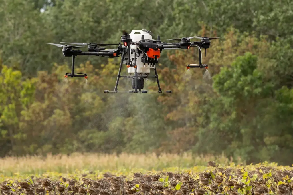
3. Crop spraying: The use of drones to provide spray treatments is already common in some areas. Drone sprayers for agriculture can reach locations that are difficult to reach, like steep tea plantations at high heights. Drone sprayers eliminate the need for personnel to traverse fields with backpack sprayers, which can be dangerous to their health. Drone sprayers apply very tiny spray treatments that may be targeted to particular locations, increasing efficiency and lowering chemical costs.
4. Crop monitoring: The biggest challenge in farming is the size of the fields and the inefficiency of crop monitoring. Increasingly variable weather conditions worsen monitoring issues, increasing risk and field maintenance costs. Previously, satellite imagery was the most advanced form of monitoring. But there were drawbacks too. Drones can provide precise field mapping including elevation information that allows growers to find any irregularities in the field. Knowing the elevation of a field helps determine drainage patterns and wet/dry zones, allowing for more effective watering tactics.
5. Irrigation: Drones equipped with hyperspectral, multispectral, or thermal sensors can detect areas of a field that are dry or in need of improvement. Drones can also calculate the vegetation index, which indicates the relative density and health of the crop and reveal the heat signature, which is the amount of energy or heat the crop releases, once the crop is growing.
6. Health check: Assessing crop health and spotting bacterial or fungal infestations on trees is critical. Drone-borne equipment can distinguish which plants reflect various quantities of green light and near-infrared light by scanning a crop with both visible and near-infrared light. This data may be used to create multispectral pictures that track plant changes and indicate their health.
A quick response may be able to rescue a whole orchard. Furthermore, once a disease has been identified, farmers may more accurately administer and monitor treatments. These two options improve a plant’s capacity to resist illness. In the event of crop failure, the farmer will be able to easily document losses for insurance claims.
Benefits of Drone Technology
As innovators introduce new technologies, their commercial uses increase day by day. As drone technology solutions become more common, it also becomes more cost-effective. In agriculture, they have a plethora of advantages. Some are as follows:
Enhanced Production – The farmer can enhance production capabilities through comprehensive irrigation planning, adequate monitoring of crop health, increased knowledge about soil health, and adaptation to environmental changes.
Effective and Adaptive Techniques – Drone use allows farmers to receive regular information on their crops and aids in the development of more effective agricultural practices. They can adjust to changing weather conditions and utilize resources efficiently.
Greater safety of farmers – Using drones to spray pesticides in difficult-to-reach terrains, contaminated areas, higher crops, and power lines is safer and more convenient for farmers. It also helps farmers avoid crop spraying, resulting in less pollution and chemicals in the soil.
Faster data for quick decision-making – Drone surveys provide farmers with reliable data processing, allowing them to make quick and deliberate judgments without second-guessing, saving time spent on crop scouting. The drone’s various sensors allow it to capture and analyze data from the entire field. The information may be used to target issue regions such as sick or unhealthy crops, various colored crops, moisture levels, and so on. The drone may be outfitted with a variety of sensors for different crops, allowing for a more precise and flexible crop management system.
Less wastage of resources – Drones in agriculture enables optimum usage of all resources such as fertilizer, water, seeds, and pesticides.
99% Accuracy rate – The drone survey helps farmers calculate the exact land size, segment the various crops, and indulge in soil mapping.
Useful for Insurance claims – Farmers utilize the data collected by drones to file crop insurance claims in the event of damage. While being insured, they even analyze the risks and losses linked with the land.
Evidence for insurance companies – Agricultural drones are used by agricultural insurance companies for efficient and reliable data. They document the damage that has happened to calculate the appropriate monetary compensation for the farmers.
Drones have changed the course of obtaining data in almost every type of industry, and will only deem to become bigger and better in the coming years. Drones have already vastly altered the agricultural industry and will continue to grow in the coming years. While drone use is becoming more useful to small farmers, there is still a way to go before they become part of every farmer’s equipment roster, particularly in developing nations.
Ready to start Agricultural Drones Services? Contact KnackForge’s Drone technology experts Today to Get Started!
]]>However, there are more benefits to using drones in the construction lifecycle than just site inspection and promotion. Recently companies are exploring other potential benefits of drones to improve worksite productivity, automated asset audits, safety detection, and validating contractor claims for payment.
Drones are effective in data collection and project tracking helping site managers analyse the project from an overarching view and ensuring that everything is going according to plan.
There are plenty of tangible benefits that can be delivered from incorporating drone data gathering into your construction workflows and decision-making processes.
Here are 5 ways drones can help AEC projects improve on-site productivity and ensure project success.
1. Capturing unique site insights
Drones can survey hundreds of acres in a couple of hours. These aerial cameras collect more site data in a shorter period of time that can be used for land surveying and to generate 3D models and maps. These 3D models are crucial for engineers, architects and construction planning helping them in almost every stage of the construction project. These maps and models are used to identify issues, help in the design of engineering and public infrastructure, report on project progress and even showcase the eventual construction in 3D space or virtual reality (VR) to stakeholders.
Drones are well suited to quickly survey and scan buildings, bridges, towers and large construction site areas. You can fly drones both indoors and outdoors to capture the entire site area, including underground, high rise buildings and more.
Some companies are also using cutting edge payloads (thermal cameras and LiDAR) for up close, aerial asset inspections to identify structural defects and resolve them in real time.
For engineering companies, drone inspections ensure maximum value for site planning and maintenance activities as there is more detailed information on existing conditions easily gathered using drones that can avoid wasted time and resources for maintenance activities that are not required or can be delayed until a later date.
For some construction companies drones are providing significant savings in logistics planning and operations by scheduling deliveries just in time using drones to inform site activities and inform schedules on a daily basis.
These are just some of the innovative ways the AEC industries are utilising drone technology but there are plenty more use cases emerging everyday.
2. Improved On-Site Safety:
Safe Work Australia is a government body that develops national policies relating to work health and safety and also records fatalities across all sectors in Australia
According to the reports by Safe Works Australia, about 16% of workplace fatalities were in construction, with the sector employing 9.2% of the workforce.
Most construction workers lose their lives on site by falling from high rise platforms. Other causes of on site casualties include, being crushed under heavy machinery, electric shocks, asphyxiation etc.
To prevent such fatalities on the site, companies are opting for drones to replace manual inspections and fixed CCTV camera installations. Instead of sending workers into difficult working conditions you can use a drone to inspect down pipelines or up high towers and buildings. Its alot safer and faster to just use a drone for the job in many instances.
For inspections, drones aid automated defect detection through aerial asset inspection, helping contractors identify and eliminate risks thereby improving workers safety, informing repairs and maintenance and having more information about the existing conditions.
3. Reduced Downtime
A construction site is nothing short of a battlefield with so many things happening at once! It is very difficult for project managers to keep track of everything happening onsite at anytime.
In construction projects, the onsite risks are both physical and economical. Injuries are not only damaging to the individual but also to the company, its culture, project completion and ultimately affects the bottom line.
Drone technology helps contractors reduce operational downtime and cut down on project costs.
They help project managers with asset management, stockpile inspection, and keeping track of raw materials, staff and machinery onsite. You can keep a record of every brick, steel girder, cement bag and plant at the site and see exactly what goes where or easily check what is not where it should be.
This prevents workers from decreased productivity and ensures that you are not overcharged by your contractors for claims for payment. It’s surprising that many companies don’t have a proess to validate contractors’ claims for payment on large construction projects. When it really can be so simple to check.
I would recommend you hire a professional team of drone experts to help you with site data collection and analysis. The drone data is only as good as the specific insights that an industry-specific company can provide with detailed analysis and reporting. Its of little use to have hundreds of photos of a construction project, but can be essential to have surveying drawings and accurate sitemaps of the project to share with site engineering and project teams.
It can be confusing to understand the difference and navigate those that can deliver accurate, measurable and repeatable data versus those that can really only deliver you pretty pictures and videos. Its important to partner with a company with the industry-specific understanding, experience and analysis to turn drone data into meaningful project insights.
A few things that the competent drone service provider will consider on your project requirements:
- What is the data to be gathered and to what specifications?
- How accurate do you require the measurements to be?
- What CRS and datum are to be used?
- How often do you need this data supplied?
- How and where are you using the supplied data and for what purpose?
- What systems and GiS applications will you incorporate the data into?
4. Preventing Expensive Mistakes
Contractors often use drones to conduct the preliminary site inspection before commencing any construction activities on the location. It is very cumbersome to manually inspect every corner of the site to ensure that it is ideal for the construction project.
With drone surveying you can cover a large area, capturing the topography and environmental attributes of the site. Identifying issues and site planning requirements to ensure the project starts and continues with little disruption.
This drone survey also gives you a holistic idea of the neighbouring locations, surrounds and local environment etc. Using this information, you can gauge the cost of procuring and transporting raw materials from one location to the site, including planning access and minimising costly delays.
Site analysis and drone surveying is extremely effective for road construction projects as it plays a major role in engineering, planning, issue detection and ultimately preventing expensive mistakes.
The images captured by drones are geo-tagged and can be live streamed to project managers for accurate real-time insights. This kind of immediate feedback helps to identify immediate challenges, obstacles, design flaws, potential accidents onsite that can be managed and avoided.
For instance, you can check out this short video to explain how we use drones to monitor and report on a road construction project in Victoria.
5. Transparent Project Updates
Drone data can be manipulated and processed into a multitude of products and easily into more accessible file formats.
The drone gathered data combined with other onsite techniques can be validated and converted into 2D maps, 3D models, images, videos, virtual reality visualisations etc. depending on your project requirements.
The most common format is to feature the drone footage on your website, social media and company communications or business proposals.
When professionally edited, drone footage combined with some visual storytelling skills, presents the project in an easy to understand and impressive format that your clients, investors and stakeholders can easily understand and consume. This often builds trust and confidence in the company and its staff and can help a business in securing larger contracts in future.
Construction projects often stretch over longer periods and stakeholders and clients need regular updates to ensure that the project is on schedule and key milestones are met. Using drones to capture onsite activities at key stages of the project helps with transparent project reporting and giving your clients and stakeholders immediate updates on the project success.
The bottom line
Drones have only emerged as useful tools in AEC industries over the last 10 years and have proven to be an absolute game changer for the AEC industries who are adopting this technology.
If you are new to drone technology, I’d recommend you hire a professional drone services company to ensure you optimise the use of the technology for more than just the basics.
Drone experts are well versed about the CASA regulations and have the necessary training and licenses required to fly drones commercially in Australia.
You can reach out to our drone experts at Avian and Just Drones for your drones sales and drone services needs.
About the author
Chris Patchell is the General Manager and Director of Operations at AVIAN Australia. He is
an avid drone enthusiast and loves innovative technologies. Chris is highly motivated with a hands-on approach to drones, surveying and laser scanning and his goal is to create awareness about drone
technology in Australian AEC industries.
On his days off, he is often scouting locations for photogrammetry and laser scanning as a hobby.
These days you’ll find Chris in Melbourne, Australia using his drones and laser scanners
to capture and recreate the real world in digital space for a range of clients and innovative applications.
]]>This Yuneec Typhoon H drone is “ready out of the box” to fly, so there is no need to spend a lot of time figuring out how it works. Someone with a beginner’s knowledge of drones can easily fly the Yuneec Typhoon H with confidence. This price point is higher, so it will likely appeal more to someone who is using the drone with the goal of moving on to a professional drone.
Perhaps you are a professional photographer and would like to add drone photography to the services that you can offer clients. Or you are a travel writer and want to use a top quality drone to capture the stunning sights you visit for publication. This Yuneec Typhoon H is the drone to select if you are new to using drones, but are determined to obtain professional level results with your images and videos.
The Yuneec Typhoon H review will also greatly appeal to that drone flyer who wants to upgrade to a better drone. They may have flown drones for awhile, but now they really want the best videos from their flights by the ocean. The camera is top-notch and has Ultra HD 4K video and a CGO3+ camera.
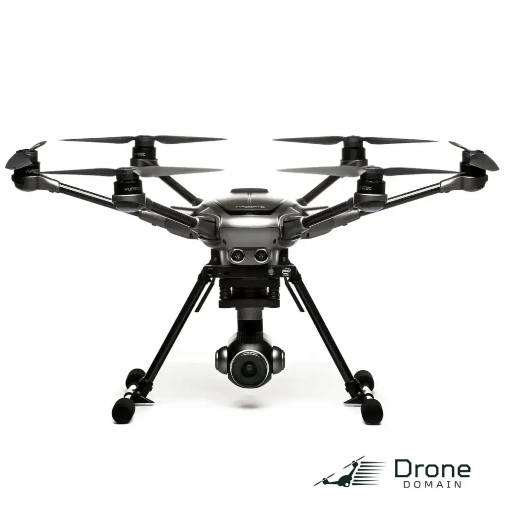
If you have a family member or friend who is a dedicated and passionate hobby photographer, the Yuneec Typhoon H is also the perfect drone to get them. Because they will simply fall in love with the capability of the camera for images and video. The simple fact that they can get started right away with this drone means they can enjoy it instantly, instead of spending their time reading instructions and tearing their hair out. The Yuneec Typhoon H is a very “friendly” professional quality drone meant for consumer use.
See the difference between the new H+ and the original:
Into Drone Fishing? See: SwellPRO Fisherman Drone FD1 Fishing Basic Bundle
Yuneec Typhoon H Review: Top Features and Characteristics
- This is a drone you actually can fly right out of the box. But what will impress drone enthusiasts is that the Yuneec Typhoon H is a professional quality drone with awesome features. In minimal time, you’ll be up in the air. You simply can’t say that about every drone out there.
- The Yuneec Typhoon H is an award winner. The Winner of the 2016 Consumer Electronics Show ‘Best of Class.’ The drone won because they delivered a professional, high-end quality drone for consumer drone users.
- You have a generous flight time of 25 minutes. It is easy to fly your drone to where you want to go. You’ll even have time for another flight, depending on where you want to be.
- Your Yuneec Typhoon H has a ST 16 controller that is all-in-one. You do not need to use either a cellphone or a tablet with your Yuneec Typhoon H drone.
- Always feel confident when you fly your Yuneec Typhoon H, as it comes complete with built-in collision avoidance. The Intel (r) RealSense Technology will quickly get around anything in the drone’s path. This is especially appealing as a beginner can fly this drone. You have less to worry about when it comes to collisions too.
- The Yuneec Typhoon H in this review has 8 smart flight modes. Even a beginner can fly this drone with top-notch technology, including automatic return to home and auto takeoff. It is quite intuitive and “user friendly.”
- This drone has a professional quality camera, with 4K video in Ultra High Definition and 12 megapixel photos. What really pleases us is the unique feature of “team mode”, so if you are flying with others, no one needs to film if the other(s) are flying.
- Not every beginner would feel confident flying a professional quality drone. But with the Yuneec Typhoon H, you can. The instructions have you in flight quickly. All of the technology has been created to have you enjoy using the drone, whether flying and/or taking videos and images too.
- We know what will really impress you about the camera; you have the ability to rotate it a full 360 degrees, to see anything you desire. You also get a great wide-angle lens and manual camera settings as well.
- Price of the Yuneec H Typhoon $1,199.00
Yuneec H Typhoon Specifications
- Size: 21.2″ x 17″ x 12.5″
- Weight: 12 pounds
- There is a limited warranty available for the Yuneec H Typhoon.
- Amazon star rating: 4 stars
The Review
Yuneec Typhoon H drone
PROS
- Good low light camera
- Water resistant
- Double the internal capacity
CONS
- Lacks clear upgrades
- Same design used for last three phones
- Battery life unimpressive